|
|
|
|
|
|
|
Coldwater and the Mississippi River Gorge
by Susu Jeffrey and Alan Olson
April 2007
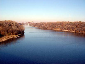
The Mississippi River gorge is the only true river gorge on the entire 2,350-mile length of the river. The gorge runs between the confluence of the Mississippi and Minnesota rivers, northward to the Falls of St. Anthony and is 1,273-feet deep according to a sign in Minnehaha Park. But it's invisible to us, filled with glacial debris and under water because dams keep the river level artificially high enough for barge traffic—9-feet deep in the shipping channel.
The old stories of being able to walk across the Mississippi meant that in low water periods, people could cross the rocky river course atop 1,273 feet of rocks deposited by the glacial melt about 10,000-years ago. The rocks that fill the gorge were brought south by glaciers that dropped their loads in the melt outwash. The glaciers ground up and pushed granite rock from the Canadian shield in (what is now) northern Minnesota southward, mixed with any other bedrock the ice mountain could scour.
A truck load of Mississippi River bottom pebbles, from dredging to keep the barge lane clear, was dumped in a friend's yard for their rock circle. The rocks are free, truck delivery is the only charge. In their circle are the tumbled remains of the earth history of this area: black granite, red stones rich in iron, white-ish limestone, milky quartz, a few pieces of sandstone, an occasional agate, and many composites. Each small stone is as individual as a person.
Rock wise, the river bottom doesn't look like the great, steep bluffs carved by the Mississippi. This is the "upper" Mississippi, the river is still on top of bedrock—considered a young river. Further south, the Mississippi meanders through layers of silt, an old river characteristic. From Cairo, Illinois, where the Ohio empties into the Mississippi, down to New Orleans, the river meanders through a sediment-filled valley 40-70 miles wide that used to be an embayment of the Gulf of Mexico.
Coldwater Spring is on top the Mississippi bluff, half way between Minnehaha Falls and the confluence of the Mississippi and Minnesota rivers. The spring is estimated to be 10,000 years old, flowing at about 100,000 gallons a day. The Mississippi bluff below Coldwater is 451-million years old—only 451-million years old. (The earth is estimated to be 4 ½-billion years old.) Between 451- and 438-million years ago, in just 13-million years, the entire bluff we see today was formed. The rock sandwich of limestone, sandstone and shale was laid down under a series of great inland seas of various depths.
>> continued here from home page >>
The bedrock through which Coldwater flows is 440-some-million year old limestone. Limestone is composed of sea shell creatures whose exoskeletons decayed at the bottom of the waters. Limestone spring water is rich in calcium and magnesium; Native people speak of Coldwater as "medicine" water.
The story that the bluffs along the river tells us, is of the comings and goings of a shallow tropical sea. The rocks record the lives that inhabited that sea.
If you were floating here at the time of this sea, and you were to look toward the southwest, you would see a chain of very high mountain islands—on the order of Mount Everest! The line of mountains stretches from the southwest, toward the northeast—the St. Cloud Mountains. In the seas around this archipelago were a variety of life forms.
This was still rather early in the evolution of life, all of the animals were invertebrates—nothing yet with a backbone. The first early plants began to come ashore at this time. Fossil remains of Trilobites, Brachiopods, Bryozoans, Crinoids, Clams and Corals are abundant in the rocks of the bluffs.
Starting at the bottom of the bluff, at river level, St. Peter Sandstone is visible. This is a layer of soft sandstone that hundreds birds have pecked nests into. It's also the layer containing the many "caves" along the river; the caves are actually manmade tunnels. The St. Peter preserves a near-shore or beach environment. 450-million years later it is still great sand for making sand castles.
Coldwater Falls cuts through this soft stone just before the creek empties into the Mississippi. Looking across the Mississippi from the east bank, the waterfall is best seen in winter—an astonishing white vertical slash.
At the mouth of Coldwater Creek, where it empties into the Mississippi, a big mechanical wheel lies, stuck in the mud. It appears to have been part of a belted pulley system. Historian Dave Fudally, citizen activist who led the effort to get the Minnesota Historical Society pioneer plaque erected in 1990 at Coldwater, sheelishly admitted he knew how the runaway mechanism arrived in place. Fudally said when he was a kid exploring the river bluff, he and a friend gave it a push down the bluff. Fudally is the source of the modern rediscovery of the Coldwater area.
Sitting atop the St. Peter Sandstone, is Shakopee Shale. It's only about 1-to-2-feet thick, a gray-green color. Shakopee shale is from a time when the sea level rose and mud washed out from the nearby land mixed with calcium rich mud of deeper water to bury earlier beach sand. This shale is notable for its lack of fossil remains.
The series of layers atop Shakopee Shale is called Platteville Limestone. The rocks of this layer are the most striking feature of the river valley. These rock walls form the picturesque steep bluffs that people associate with the upper Mississippi.
Soldiers who lived at "Camp" Coldwater and built Fort Snelling (1820-23) created limestone bricks, mined on-site out of the bluffs. Platteville Limestone was used in many of the major buildings in downtown Minneapolis and St. Paul and in home foundations throughout the Twin Cities.
The limestone is a record of when the sea reached its deepest level. Sediments deposited turn to limestone from the presence of countless microscopic shells dropped from plankton as they die off each year. Calcium in the shells helps to turn the mud into limestone under pressure as the layers weigh down on each other and are cemented into rock.
Embedded in the top third of the Platteville limestone formation is an interesting feature—the Deike K extinction event. This is a layer of brown shale-like rock deposited in a monumental volcanic event that has been estimated to be about 400 times the size of the Mount St. Helens blast in 1981.
The Deike K volcanic explosion event deposited ash up to 4-feet deep in just a day over as much as a quarter of the globe. Due to the bottom dwelling mode of most life forms at the time, it caused a regional extinction and created a biological desert in this area. No fossils are found in the limestone for 2-feet above the ash layer—about 250,000 years in time.
The final layer of the Mississippi bluff is Decorah Shale which sits on top of the Platteville Limestone. Decorah Shale represents a time when the sea level was dropping again and so contains a good amount of mud washing off the nearby land. Decorah Shale is fossil rich. In most cases the shale has weathered to the point that it is like very loose soil and the fossils can simply be picked out with your fingers. This shale layer is quite thick, 25-30 feet, and is gray-green in color. There was a large brick yard on the St. Paul side of the river that turned shale into the paving bricks used in our city streets in the early 20th century. It is still a wonderful place to look for fossils.
What happen here between 438-million years ago and 10-thousand years ago was literally erased by the glaciers. The massive mountains of ice scraped clean every trace of millions and millions of years of earth history. Our rich prairie soil is glacial deposit atop 438-million year old limestone and shale.
Melt water from glacial Lake Agassiz shaped the broad Minnesota Valley. The narrow upper Mississippi, before its confluence with the Minnesota, looked like a creek in comparison. Imagine a 2-mile wide waterfall thundering between the bluffs in what is now St. Paul. The Falls of St. Anthony is a remnant of that great Mi-ni Ha-ha (Dakota for waterfall, literally "the noise of waterfalls").
One of the consequences of the glacial history of our area is that we have no native earthworms. Our forests evolved without worms which munch through the forest floor, the "duff," too quickly for the vegetation to absorb compost nutrients. Fisherpeople throwing out unused worm bait are responsible for the local earthworm population—a mixed blessing, good for gardens, hard on forests. The Minnesota Department of Natural Resources advises people who fish "to slow the earthworm infestation by dumping unwanted bait in the trash and keeping vehicles on well-traveled paths" because worm eggs are spread through soil caught in tire treads.
Unintended consequences of seemingly positive human behavior continue to get us into trouble. The Green Revolution was supposed to combat hunger. The result was a huge population increase and then millions and millions of starving people, overworked soil, growing deserts and fouled drinking water. The earth has its own timeline, and when we violate it, earth's resources backfire on us.
Coldwater is the last natural spring in Hennepin County, the only place where you can drink water as it pours out of the bedrock. As a 10,000-year old spring atop a 450-million year old rock layer cake, Coldwater gives a different perspective to time and humanity. Coldwater is the most ancient living resource the Twin Cities.
The National Park Service announced it will determine the future of the 27-acre Coldwater campus, the old Bureau of Mines complex abandoned since 1996, in 2007 or 2008. In a preliminary report the site was defined again and again as sacred to Native Americans. A federal treaty rights case resulted when private federal security guards refused to allow people on-site to gather water and pray. The case is pending.
After the World Trade Towers disaster (9/11/01) and the resulting airline financial crash, the plan to sell the Coldwater campus to the airport for parking fell through. The site devolved back to the Department of the Interior, managed through the U.S. Fish and Wildlife Service. In 2003 Congressman Martin Sabo secured a $750,000 appropriation to lead the process to determine the "disposition" of the Mississippi blufftop acreage. In the beginning of the process top local National Park Service officials thought Coldwater was "too complicated" and simply wanted to unload it. However citizen pressure has dogged and slowed the process.
Coldwater's future will be a political decision.
Susu Jeffrey is the founder of Friends of Coldwater.
Alan Olson is a lifelong rock and mineral collector and a goldsmith by profession. His long-term interest in the story told by the fossil record led him to spend four years as a volunteer interpreter in the Paleontology Hall of the Science Museum of Minnesota. In 1996 he started Lifestone Fossil Co. He has spent the last 10 years as a field collector of dinosaur fossils in eastern Montana and is active in the Twin Cities rockhound and Earth sciences communities. In May of 2006 Olson led the monthly Full Moon Walk around the Coldwater area. |
|
|
|
|
|
|