|
|
|
|
|
|
|
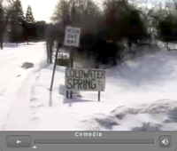
Hear the Spring Sing
Full Moon Walk
at Sacred Coldwater Springs
Wednesday, June 11, 2025
Gather at the park entrance, 7 pm
Park on the Hwy 55 access road
|
|
Coldwater Spring
By Tiffany Eggenberg
Coldwater Spring
I can hear her sing
I visit her to purify and cleanse
To absorb the vibration she sends
I visit her to feel serene
To absorb the calming scene
I visit her to offer a prayer
Because I truly care
I know I’ve made a good choice
When the sound I hear is her voice
Coldwater Spring
Can’t you hear her sing?
The feeling she gives is so tranquil
I pause at the view from the top of the hill
I enter the labyrinth on a path
Pure and welcoming, a spiritual bath
My ancestors gathered here
To me, the reason is clear
I visit her to feel the heartbeat
Where people and waters meet
Coldwater Spring
Can’t you hear her sing
---
Coldwater has been flowing about 11,000-years—even under the last glacier.
Coldwater is an acknowledged Dakota sacred site. Friends of Coldwater seek to honor our 11,000-year-old landscape ancestor and the people whose dust we stand upon. So we return and return to remember the spirits that feed this sacred place.
Full moon walks have been celebrated at Coldwater Springs each month since 2000, that’s a quarter of a century of paying attention. Traditional group howl when the moon peeks out.
Sunset 9 pm (28-minutes later than last full moon)
Moonrise 10:04 pm (57-minutes later than last month_
15-hours, 33-minutes of daylight (49-minutes more than last month)
Moment of the full moon: 2:44 am
Raindrops take 8 minutes at 14.5 mph to reach Earth from 10,000 feet.
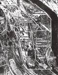
DIRECTIONS: Coldwater Springs is between Minnehaha Park & Fort Snelling, in Minneapolis, just north of the Hwy 55/62 interchange. From Hwy 55/Hiawatha, turn East (toward the Mississippi) at 54th Street, take an immediate right, & drive all the way down the frontage road where you can park at the pay meters.
Gather at the cul-de-sac, which is the Coldwater Park entrance.
Free. All welcome.
|
|
|
 |
|
|
|
|
|
|
|
| View the Friends of Coldwater slideshow |
|
|
|
|
|
|
|
|
|
|
|
|
|
KFAI Radio: MinneCulture |
|
|
|
| PLEASE NOTE: THIS IS A QUICKTIME FILE. QUICKTIME MUST BE INSTALLED AND ENABLED TO LISTEN. |
|
|
|
|
|
 |
|
|
|
|
Coldwater Spring/
Mini Owe Sni
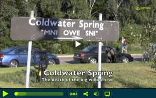
Hear John Anfinson of the National Park Service declare "We begin history here in 1820." In 1820 U.S. Army troops marched up the Mississippi bluff to Coldwater Springs, assumed control of the land and water, and mined limestone out of the hillside to build Fort Snelling.
Coldwater Springs has been flowing more than 10,000 years and still flows at 80,000 to 90,000-gallons a day. Coldwater is half way between Minnehaha Falls and the confluence of the Mississippi and Minnesota rivers; it is part of the Dakota genesis story and considered sacred.
In 2010 the National Park Service took over Coldwater's 27-acres with the congressional mandate to restore it as public parkland. In December 2011 park officials had the area clear-cut including indigenous cottonwoods, maples and sumac bushes. The 2006 and 2009 NPS Environmental Impact Studies included airport rules and maps delineating runway rights-of-way where "no new trees" can be planted.
Native peoples and environmental activists are pressing NPS for a more inclusive history at Coldwater and a more natural, less corporate McPark look. (See NPS park plans here)
KFAI producer Allison Herrera explores the history of Coldwater Springs in this exclusive MinneCulture documentary. |
|
|
|
|
|
|
|
|
|
| The Willow Weeps No More |
|
 |
|
By Bill Sorem
August 2011
The giant willow by the source of historic Coldwater Spring has been cut down. The National Park Service removed the tree claiming it was a hazard and could damage Coldwater reservoir. The tree was also showing its age with decaying wood, cracks and weak branches.
The spring has been there an estimated 10,000 years and was long a sacred site for the indigenous peoples, probably preceding the current Anishinabe and Dakota people. It was once Camp Coldwater, an adjunct to Fort Snelling. Troops and settlers were quartered there and water was hauled down to the fort, with a pumping system deployed in later years. It was a source of water for the fort from 1820 to 1920.
From the 1950s to 1991 the Coldwater property was a Department of the Interior, Bureau of Mines research center. The site was transferred to the Park Service in 2010. When MnDOT rebuilt the Highway 55/62 interchange they did so without the required environmental assessment, claiming that they would prevent any harm to the spring. Their construction caused a loss of more than 27,500 gallons a day. The spring is currently flowing about 90,000 gallons a day.
Susu Jeffrey, founder of Friends of Coldwater, led a Full Moon Walk on August 13, 2011, to visit the old willow before it was cut down. She has lobbied, worked and written for the preservation of this historic area. Visitors sprinkled a circle of corn meal around the tree, celebrating its life and vitality. Some branches were clipped to be sprouted for future descendants of the tree.
Plans for development remain uncertain as the nation wrestles with budget issues and a group in Congress wants to defund the National Park Service. Thus the sacred spring and its environs are left in disarray.
|
|
|
|
|
|
|
|
|
|
Regarding the Willow...
An Open Letter to the National Park Service |
|
From: Sheldon P. Wolfchild, Dakota leader from the Lower Sioux Indian Reservation in Morton, Minnesota
To: John Anfinson, Ph.D., Chief of Resource Management for the Mississippi National River and Recreation Area (MNRRA) of the National Park Service
August 10, 2011
Subject: Removing "Sacred Willow Tree at Sacred Site"
Mr. John Anfinson:
The Dakota people who respect and honor our Sacred Sites and the natural vegetation surrounding these sites (which include specific sacred trees such as our willow trees!) and in particular the Sacred willow tree at our Dakota Sacred site Coldwater Spring, are requesting you grant the wish of our elders and spiritual leaders to put a stop on cutting down our Sacred willow tree at Coldwater spring.
As you should know by now the Department of Agriculture and the National Park Service met last March 11th in Phoenix, Arizona, with many Spiritual leaders and Elders to include new rules and guidelines for the protection and use of Sacred sites and the natural plant and tree medicines to be used by the indigenous of this country.
We ask that you call and stop this willow tree removal immediately.
This message will be sent to all our spiritual people across the country.
Sheldon Wolfchild |
|
|
|
|
|
|
|
|
|
Friends of Coldwater Comment on the FEIS for the Coldwater/Bureau of Mines Property.
Friends of Coldwater recommendations for Coldwater Park
NPS / MNRRA Ownership
We support National Park Service/Mississippi National River and Recreation Area management and ownership of Coldwater for all peoples. Traditionally the Coldwater area was a "neutral, sacred" place where all nations gathered together and gathered water for ceremonial use.
Expand Coldwater Park
Expand Coldwater Park (27 acres) to include the adjacent Veterans Administration blufftop parcel (23 acres) and the Minnesota Historical Society bottomland (21 acres) to form one contiguous park linked to the National Park Service Island (108-01) in the Mississippi directly below Coldwater (see attached map).
Green Museum
Coldwater is an ancient geographical feature, predating human habitation here, and is the last natural spring of size (90,000 gallons per day) in Hennepin County. We urge designation of the Coldwater property as America’s first Green Museum, a place where the land itself is the museum, the teacher. Special designation would add protection since the surrounding area is highly developed and slated for more development.
Watershed Protection
After removal of Bureau of Mines buildings and structures, replanting and stabilization of the land, the enduring crucial aspect of “ownership” of this last natural spring in Hennepin County will be to preserve and protect the source water and the underground pathways of that water to the spring outflow.
Unlike other watershed districts in Minnesota, Coldwater's source waters are separated administratively from its outflow and discharge into the Mississippi. Responsibility from source to mouth should be assigned to the Minnehaha Creek Watershed District, the agency that sued MnDOT to force a redesign of the Highway 55/62 interchange that threatened 30-percent of the flow to the spring as measured by dye tests.
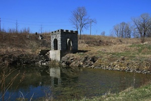
Retain the Spring House and reservoir (pond) as-is to "partially reflect more than one period in history." Also since the greatest outflow of spring water is at the northwest corner of the Spring House, removing the Spring House with its shade could damage the outflow.
During the Bureau of Mines period when the property was fenced and closed to the public, Coldwater was used as an emergency drinking water supply for south Minneapolis. “In 1976 after months of drought the city water developed an algae that was putrid and undrinkable by my husband who was very sick at the time. I made trips every other day to Coldwater Spring and stood in line to get the best tasting fresh water. We were so thankful for this vital resource. If it is still not polluted it should be a National Treasure!” (Carolyn K. Lyschik, 13805 Glasier Lane, Little Falls MN 56345, written statement dated 10/21/06, [month and year certain, date hard to read] original included with DEIS comments).
With a worldwide clean drinking water crisis and climate change it would be wise to preserve our county’s last natural spring.
footnotes - click here » |
|
|
|
|
|
|
|
|
|
|
Friends of Coldwater
Green Museum initiative... |
|
 |
|
| A Land Use Vision for Coldwater Park |
|
Coldwater Spring has been flowing for 10,000 years, experts say, even under the last glacier. The 27 acre Coldwater campus is located atop the Mississippi River gorge, between Minnehaha Regional Park and Fort Snelling State Park, just above the confluence of the Minnesota and Mississippi rivers. Coldwater furnished water to Fort Snelling for a century and still flows at about 100,000 gallons a day.
Coldwater is the Birthplace of Minnesota, where the soldiers who built Fort Snelling lived (1820-3) and where a civilian community developed to service the fort. Those settlers founded Pig's Eye (later St. Paul), St. Anthony, Minneapolis and Bloomington, setting the stage for Minnesota statehood in 1858.
Before European immigration into what is now Minnesota, the 2.5-mile stretch from Minnehaha Falls—to Coldwater—to the confluence of rivers, was a traditional gathering place for upper Mississippi tribes. Eddie Benton Benais, Grand Chief of the Mdewiwin (Medicine) Society, Anishinabe spiritual elder from Lac Courte Oreilles, Wisconsin, gave court-ordered testimony (3/19/99) about the cultural significance of the Coldwater area:
My grandfather who died in 1942...many times he retold how we traveled, how he and his family, he as a small boy traveled by foot, by horse, by canoe to this great place to where there would be these great religious, spiritual events. And that they always camped between the falls and the sacred water place [the spring]... We know that the falls which came to be known as Minnehaha Falls, was a sacred place, a neutral place, a place for many nations to come... And that the spring from which the sacred water should be drawn was not very far...a spring that all nations used to draw the sacred water for the ceremony...How we take care of the water is how it will take care of us...
More on the Initiative - click here »
Download the Initiative as a .PDF - click here » |
|
|
|
|
|
|
|
|
|
GREEN MUSEUM
A Land Vision for Coldwater Park |
|
| Friends of Coldwater envisions Coldwater Park as an 80-acre urban wilderness, from the top of the Mississippi gorge to the river—America’s first Green Museum—a place where the land is the legacy, the museum, the teacher and the future. |
|
| • Coldwater Spring is at least 10,000-years old. It is the last major natural spring in Hennepin County. |
|
| • Where Coldwater Creek and waterfall empty into the Mississippi River the sandstone bedrock is 451-million years old. |
|
| • At the top of the bluff where Coldwater Spring flows out of bedrock fractures, the limestone is 438-million years old. Everything after that time was scraped south by glaciers (which is why there are no native earthworms). |
|
• Mni Owe Sni (Dakota: water-spring-cold) located above the confluence of the Minnesota and Mississippi rivers, was a traditional gathering place for Upper Mississippi Indian peoples including Dakota, Anishinabe, Ho Chunk, Iowa, Sauk and Fox (within historic memory). Particularly blessed by water and considered sacred was the 2.5-mile stretch from (what is now called) Minnehaha Falls through Coldwater to the b’dota, the meeting of waters (confluence).
• Coldwater became the Birthplace of Minnesota when army troops camped around the spring (1820-23) and mined limestone bluffs to build Fort Snelling. Pioneers built cabins at “Camp” Coldwater to service the fort with meat, trade goods, whiskey, translators, guides, wives, domestic workers and missionaries. Coldwater furnished water to the fort from 1820-1920. |
|
| • From the 1880s to 1950 “Coldwater Park” was labeled on area maps. |
|
| • The Bureau of Mines built a Cold War facility to research metallurgy and mining on 27-acres around Coldwater, 1950-95. |
|
| • In 1988 the US Congress established the Mississippi National River and Recreation Area, under the National Park Service. MNRRA is a 72-mile long spaghetti-shaped parcel of critical habitat along the Mississippi River through the greater Twin Cities from Dayton to below Hastings. Coldwater could become the jewel of MNRRA. |
|
| • Coldwater still flows at about 80,000 gallons a day. |
|
|
|
|
|
|
|
|
|
| FLASHBACK: Take a 2008 Virtual Tour of Coldwater |
|
A Sacred Place
A video by Sid Pranke and featuring Friends of Coldwater founder Susu Jeffrey.
Take a short video tour of Colwater.
View the video -
click here »
|
|
|
|
|
|
|
|
|
|
| Coldwater History |
|
Coldwater is a 10,000-year-old spring that flowed at a pre Highway 55 construction rate of 100,000-144,000 gallons a day.
In addition to being a living geological museum, Coldwater was a traditional gathering place for Native American tribes of the upper Mississippi that used spring water for specific ceremonies requiring sacred water in a sacred landscape.
The powerful Dakota god of waters and the underworld is said to dwell at Coldwater Spring.
Coldwater is also the birthplace of Minnesota, where the soldiers lived who built Fort Snelling and site of the pioneer settlement whose citizens founded St. Paul and Minneapolis. Coldwater furnished water to Fort Snelling for 100 years.
Minnehaha Falls is about a mile north of Coldwater Spring. Both are on the Mississippi River bluff that forms the only true river gorge on the entire 2,350-mile length of the Mississippi. The gorge runs 9 miles from the confluence of the Mississippi and Minnesota rivers to the cataract now called the Falls of St. Anthony...
(continued - click here »)
LEARN MORE:
Camp Coldwater Facts - click here |
|
|
|
|
|
|
|
|
|
|
|
|
|
|
|
|
|
|
|
|
 |
|
| Before it was a historic site, Coldwater was a sacred site. |
|
| Coldwater Journal is a record of personal observations and reflections from visits to the Coldwater campus. |
|
|
|
|
An Inconvenient Law
By Susu Jeffrey
|
|
|
|
|
|
|
|
|
|
|
The National Park Service clear cut Coldwater in 2011,
Photo: Friends of Coldwater
|
|
|
|
|
|
A team of us spent three years lobbying at the State Capitol to get the Coldwater protection law through committees, approved on the floor and signed by the governor in 2001.
The Law: Protection of the Natural Flow
Neither the state, nor a unit of metropolitan government, nor a political subdivision of the state may take any action that may diminish the flow of water to or from Camp Coldwater Springs. All projects must be reviewed under the Minnesota Historic Sites Act and the Minnesota Field Archaeology Act with regard to the flow of water to or from Camp Coldwater Springs.
The language of the law is specific, forbidding “any action that may diminish the flow.” Not “temporary” dewatering, not “permanent” dewatering—no “action that may diminish.”
A proposed Metropolitan Council sewer replacement construction calls for two years of dewatering and simultaneous daily monitoring of the flow at Coldwater.
Before Highway 55 reconstruction, about 130,000 gallons per day was measured at Coldwater Springs. Since 2002 there has been a constant decline—27,500 is pumped out and another 18,500 leaks away. That is a loss of 46,000 gallons per day, or 35%—more than a third.
Emergence Landscape of the Dakota Nation and Birthplace of Minnesota
Coldwater is at least 10,000 years old, the last natural major spring in Hennepin County and a Dakota Tribal Sacred Site and Traditional Cultural Property, according to the Ethnographic study commissioned by the National Park Service, which immediately rejected the findings. However the Minnesota State Historic Preservation Office agrees with the study. Before Coldwater was a historic landmark it was a sacred site.
continued » |
|
|
|
|
|
|
|
|
Who Owns Coldwater
By Susu Jeffrey
|
|
|
|
|
|
|
|
|
|
|
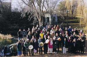
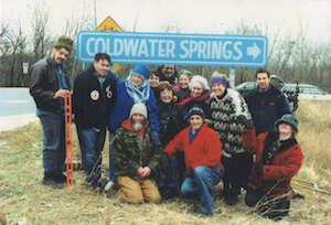
Coldwater Supporters at the Pond and Spring House, December 1991
Photo: Dick Bancroft |
|
|
|
|
|
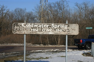
In the early 2000s Friends of Coldwater put up a sign to direct people off Highway 55 at the traffic light at 54th Street to Coldwater Springs. Some years later the Minneapolis Park Board repainted the sign their customary brown and white.
Recently I emailed the Park Board and asked who is responsible for this sign? “This sign is the responsibility of the National Park Service,” was the anonymous reply.
Not! So I phoned and yes the Park Board did paint that sign and now it looks—ah tired. |
|
|
|
|
|
|
|
|
|
|
Coldwater Springs sign designed and erected by Friends of Coldwater in the early 2000s.
Photo: Dick Bancroft. |
|
|
|
|
|
|
|
|
|
|
|
|
|
|
|
The sign today, repainted and maintained by the Minneapolis Park Board.
Photo: FoC. |
|
|
|
|
|
It is unclear who owns the land under the sign in south Minneapolis. It is probably on MnDOT highway (state) right-of-way. But it is also within the federal land included in the so-called Pike-Dakota treaty of 1805. The larger question is who “owns” the 100,000-acres of land along the Mississippi River gorge including Coldwater?
continue » |
|
|
|
|
|
|
|
|
|
|
|
|
|
|
|
 |
|
Coldwater Named a National Treasure
By Susu Jeffrey
The National The National Trust for Historic Preservation has recognized Coldwater Springs as part of the “National Treasure” that is “Bdote Fort Snelling.” Bdote, Dakota for meeting of waters, is defined as including “the entire area known as Fort Snelling: the Upper Post, Historic Fort Snelling State Park, Fort Snelling National Cemetery, Coldwater Spring[s] and the confluence of the rivers.”
Consider the awesome geography of the confluence of the Mississippi and Minnesota rivers beneath towering cliffs carved by glacial melt waters. Just upstream on the Mississippi, Coldwater Creek outflows, then Minnehaha Creek and nine miles upstream, the great falls now called St. Anthony.
The Dakota consider Bdote their place of emergence as a people. Like the Biblical Garden of Eden, the Dakota place of genesis is a spring in a garden which parts into major rivers. It is not a dot on the map but a region that provided food, shelter and all the good things of life.
Coldwater is the last major natural spring in Hennepin County. “Camp” Coldwater was the Birthplace of the State of Minnesota, the first Euro-American settlement in our state. Before the Louisiana Purchase (1803) and European expansion across North America, Coldwater was a traditional gathering and ceremonial site for Dakota, Anishinabe, Ho Chunk, Iowa, Sauk and Fox nations.
continued » |
|
|
|
|
|
|
|
|
|
 |
|
Coldwater: Sacred Site or Military Monument?
By Susu Jeffrey
The National Park Service (NPS) is imposing its vision of Coldwater Springs by recreating the landscape and the history of the place.
"Spring water is sacred," says Anishinabe teacher Dennis Jones. In 2006, the Lower Sioux of Morton declared Coldwater "and the land that surrounds it" to be a Traditional Cultural Property (TCP) and "sacred." NPS limits TCP designation to that one Dakota tribe, not all Dakota.
Collecting water at Coldwater is a humbling experience. You want to fill your jug at the precise place where the water exits out of bedrock. First, leave an offering, then bend over double, and just below your feet feel the water gushing out.
continued » |
|
|
|
|
|
|
|
|
|
|
 |
|
Coldwater: The new history
By Susu Jeffrey, September, 2012
“We begin history here in 1820,” John Anfinson said in a KFAI radio interview.
Chief of natural and cultural resources for the National Park Service (NPS), Anfinson is the architect of the Coldwater Park redux.
In 1820, U.S. soldiers took possession of Coldwater Springs and harvested limestone out of the Mississippi gorge to build Fort Snelling. They harvested oaks for firewood.
Dakota people showed Mni Owe Sni (water-spring-cold) to Lt. Col. Henry Leavenworth, who had lost 20% of his troops the previous winter due to unsanitary practices at their camp on the Minnesota side of the confluence.
The Dakota welcomed soldiers who would buffer Anishinabe threats and allow Dakota people to trade for guns and other European goods. “It’s like bringing Walmart in,” a Dakota man said. Coldwater furnished water to Fort Snelling for a century, from 1820 to 1920.
By the late 1830s, the army was forcibly evicting Swiss, French, Canadian, Irish, English and African pioneers, as well as Native Americans from the fort in order to preserve firewood and game. The Whiskey Wars and settler pressure were threatening fur trade profits.
We don’t know if Indian people were at Coldwater “because they didn’t write down their stories,” Anfinson told a Coldwater tour group in November 2011. The following month NPS contractors clear cut most of Coldwater...
continued » |
|
|
|
|
|
|
|
|
|
 |
|
Coldwater Spring debuts with a new look
Tom Meersman, September 3, 2012
A major landscape restoration project drastically changed the historic spring area, which reopens this week. Not all are pleased.
Nine months ago, one of Minnesota's most historic sites was littered with glass, trashed buildings, invasive buckthorn trees and crumbling asphalt roads.
This week, as Coldwater Spring in south Minneapolis reopens to the public, the 29-acre site between Fort Snelling and Minnehaha Park has been transformed to a natural park with oak trees and open vistas.
So far the $2.2 million makeover -- directed by the National Park Service, which owns the land -- is getting mixed reviews.
To Susu Jeffrey, an author and advocate of preserving the area, the Park Service has devastated the land.
"It's been toxified and clear-cut and then leveled," she said, adding that it now looks like a corporate, suburban "McPark."
continued » |
|
Links to Coldwater restoration plans
Link to the State Historical Preservation Office and the Memorandum of Agreement on Bruce White’s website.
Star Tribune article 10/24/11 - click here » |
|
|
|
|
|
|
|
|
|
|
| The Most Historic Land in Minnesota |
|
|
|
|
| Coldwater Spring House. 2.2.16. Photo: Susu Jeffery |
|
We don't know the names of the Native American peoples who lived around Coldwater Spring after the last glacier melt 10,000-years-ago. The Dakota people were there when soldiers camped at the Spring while building Fort Snelling (1820-3) above the confluence of the Mississippi and Minnesota rivers.
The Spring furnished water to the Fort 1820-1920 and still flows at a reduced rate of about 80,000 gallons per day. During the drought summer of 1976 when city water tasted putrid, Coldwater was an emergency drinking water supply for south Minneapolis.
Friends of Coldwater (FoC) was founded in 2001, on the shoulders of Park and River Alliance, Stop the Reroute—Save the Park, and Preserve Camp Coldwater Coalition as the movement to save this historic land and waterscape changed with passing time. In January 2010 the National Park Service/Mississippi National River and Recreation Area (NPS/MNRRA) began managing the 27-acre Coldwater property.
Friends of Coldwater is one of the consulting parties to the NPS/MNRRA Memorandum of Agreement to transition the property from industrial research campus to open parkland. Since February 2011 we have been asking, repeatedly, to see the plans before plans are finalized.
It is the frustration of arbitrary tree removal, toxic chemical application and recent land damage that leads us to the extraordinary step of writing to the regional director of the NPS.
continued » |
|
|
|
|
|
|
|
|
|
|
|
|
|
Coldwater and the Mississippi River Gorge
by Susu Jeffrey and Alan Olson
April 2007 |
|
The Mississippi River gorge is the only true river gorge on the entire 2,350-mile length of the river. The gorge runs between the confluence of the Mississippi and Minnesota rivers, northward to the Falls of St. Anthony and is 1,273-feet deep according to a sign in Minnehaha Park. But it's invisible to us, filled with glacial debris and under water because dams keep the river level artificially high enough for barge traffic—9-feet deep in the shipping channel.
The old stories of being able to walk across the Mississippi meant that in low water periods, people could cross the rocky river course atop 1,273 feet of rocks deposited by the glacial melt about 10,000-years ago. The rocks that fill the gorge were brought south by glaciers that dropped their loads in the melt outwash. The glaciers ground up and pushed granite rock from the Canadian shield in (what is now) northern Minnesota southward, mixed with any other bedrock the ice mountain could scour. |
|
|
|
|
A truck load of Mississippi River bottom pebbles, from dredging to keep the barge lane clear, was dumped in a friend's yard for their rock circle. The rocks are free, truck delivery is the only charge. In their circle are the tumbled remains of the earth history of this area: black granite, red stones rich in iron, white-ish limestone, milky quartz, a few pieces of sandstone, an occasional agate, and many composites. Each small stone is as individual as a person.
Rock wise, the river bottom doesn't look like the great, steep bluffs carved by the Mississippi. This is the "upper" Mississippi, the river is still on top of bedrock—considered a young river. Further south, the Mississippi meanders through layers of silt, an old river characteristic. From Cairo, Illinois, where the Ohio empties into the Mississippi, down to New Orleans, the river meanders through a sediment-filled valley 40-70 miles wide that used to be an embayment of the Gulf of Mexico.
Coldwater Spring is on top the Mississippi bluff, half way between Minnehaha Falls and the confluence of the Mississippi and Minnesota rivers. The spring is estimated to be 10,000 years old, flowing at about 100,000 gallons a day. The Mississippi bluff below Coldwater is 451-million years old—only 451-million years old. (The earth is estimated to be 4 ½-billion years old.) Between 451- and 438-million years ago, in just 13-million years, the entire bluff we see today was formed. The rock sandwich of limestone, sandstone and shale was laid down under a series of great inland seas of various depths...
(continued - click here ») |
|
|
|
|
|
|
|
|
|
|
 |
|
Grandmother of Rivers, The Mississippi
March 26, 2010
From Allan W. Eckert’s Twilight of Empire, footnote 12:
Indian peoples from as far east as the Hudson Valley and as far west as the Rocky Mountains referred to the Mississippi River as “the Grandmother of Rivers,” but no evidence has been discovered to indicate that they ever called it “the Father of Rivers,” which appears to be an appellation originated by the whites, probably the British. More frequently Indian people referred to it as the Mississippi, meaning “Big River.”
Derivation of Mississippi is traced most specifically to the Ottawa tongue, in which it is Misses Sepe. Variations of this in other dialects are Metha Sepe (Shawnee), Meche Sepe (Kickapoo), Mecha Sapo (Sac), Mecha Sapua (Menominee) and Meze-Zebe (Chippewa).
In these variations, the first word means big or large, the second means river. Oddly enough, the Winnebagoes referred to it as Nekoonts Haktakah—again, the two words meaning Large and River. The Sioux, on the other hand, called it Wapta-Tonga, with the two words once more signifying Big and River.
From Paul Durand’s Where the Waters Gather and the Rivers Meet:
Misi Zibi [Ojibwe, a.k.a Chippewa, Anishinabeg] “River-Everywhere-Or-All-Over, the Mississippi becomes so below the junction of Leech Lake River, not Itasca, as so designated by the whites. This is the archaic designation, as in later times it was more commonly called KITCHI [great] ZIBI [river]. (p. 131)
“Rivers follow the general rule of taking the name of their immediate source lake. When reaching Lake Bemidji, Cass, and Winnibigoshish, this stream changed its name three more times and not until the outlet of Leech Lake is reached does it become the Mississippi.”—Jos. A. Gilfillan (p. 15)
Following this rule the source of the Mississippi, with its wealth of tourism, would be within Leech Lake Indian Reservation two counties east of Lake Itasca. (S.J.)...
(continued - click here ») |
|
|
|
|
|
|
|
|
|
|
|
|
|
|
|
|
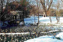
Ducks at Coldwater Spring January 6, 1998.
– photo © Susu Jeffrey |
|
|
|
|
|
|